
CREATE
  • Technology
    • BIOTECH
    • COMMUNICATIONS
    • COMPUTING
    • IMAGING
    • MATERIALS
    • ROBOTICS
    • SOFTWARE
  • Industry
    • DEFENCE
    • INFRASTRUCTURE
    • INNOVATION
    • MANUFACTURING
    • POLICY
    • PROJECTS
    • TRANSPORT
  • Sustainability
    • ENERGY
    • ENVIRONMENT
    • RESOURCES
  • Community
    • CULTURE
    • PEOPLE
  • Career
    • EDUCATION
    • INSPIRATION
    • LEADERSHIP
    • TRENDS
  • About
    • CONTACT
    • SUBSCRIBE
No Result
View All Result
CREATE
No Result
View All Result
Home Sustainability Environment

LiDAR, levees and land loss: Engineering a coastal response to rising waters

Chris Sheedy by Chris Sheedy
17 September 2026
in Environment, Features
Reading Time: 7 mins read
0

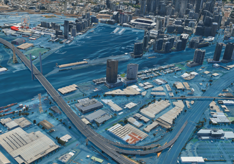
A hypothetical model of Melbourne’s Docklands experiencing five-metre flood inundation. Image: supplied / Hatch

As the inevitable reality of rising seas puts Australian infrastructure at risk, engineers are better understanding what should be protected, what can be adapted and what must be left behind.

According to the State of the Environment 2021 report, 87 per cent of Australians live within 50 km of the coast.

Having always been one of the nation’s greatest assets, Australia’s coastline is also home to the lion’s share of the country’s infrastructure, housing and economic activity. That makes sea-level rise and the increasing severity of storm events a serious challenge.

New research recently published in Scientific Reports clarifies the scale of the issue. Sea level rise could affect 267,500 properties and two million hectares of land by 2100. That represents present-value damages of more than $850 billion. That is under the moderate scenario conditions of RCP4.5 and does not include the value of environmental, cultural and infrastructure losses.

For engineers, knowing the level of risk is just the beginning. Decisions around infrastructure location, protection and adaptation will all stem from a deep understanding of exactly where and how hazards will occur.

Partly to address this issue, Hatch helped develop the South Australian Government’s Climate Ready Coasts program, which included coastal hazard adaptation planning guidance and an assessment covering around 5000 km of coastline.

Hatch’s Senior Coastal Engineer Ryan Nguyen MIEAust CPEng said the modelling project began by taking a step back to understand what already existed.

The team benchmarked adaptation planning practices in Australia and overseas, and assessed the maturity of coastal adaptation planning across South Australian councils. The assessment considered all the availability of data, the methods used and how far councils had progressed with adaptation planning. 

Turning datasets into evidence

Nguyen and his team combined decades of cross-shore beach profile surveys as well as LiDAR topographical data, national bathymetry data, current water-level studies, Bureau of Meteorology wind and wave records, and more.

They then developed semi-automated modelling tools to run various scenarios to account for different levels of sea-level rise with varied planning horizons, from present day to 2050 and 2100.

The data was then calibrated against real-world, measured sources, including severe coastal storms in South Australia in 2016, to benchmark the outcomes.

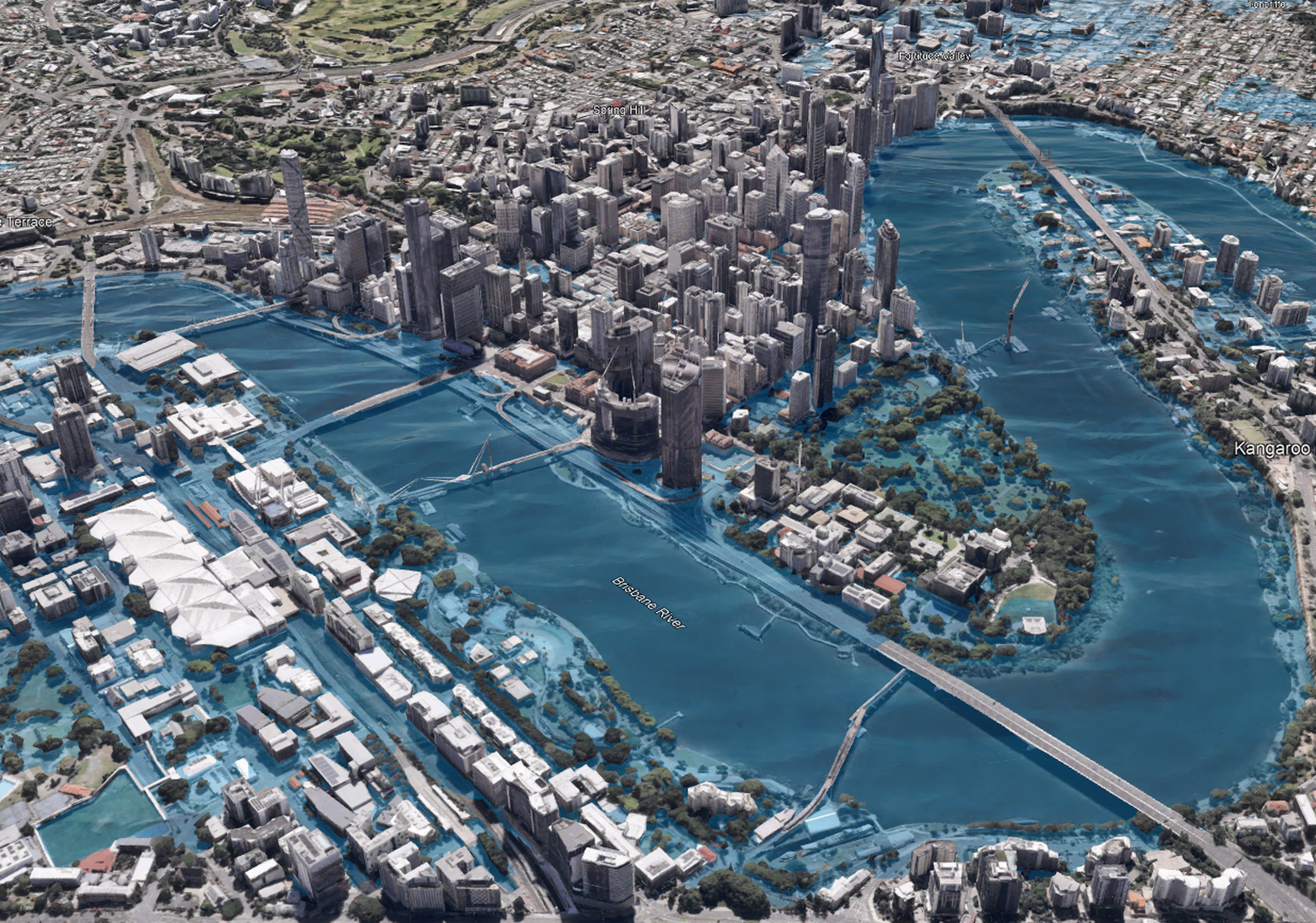
The Brisbane inundation model (for illustration purposes only)
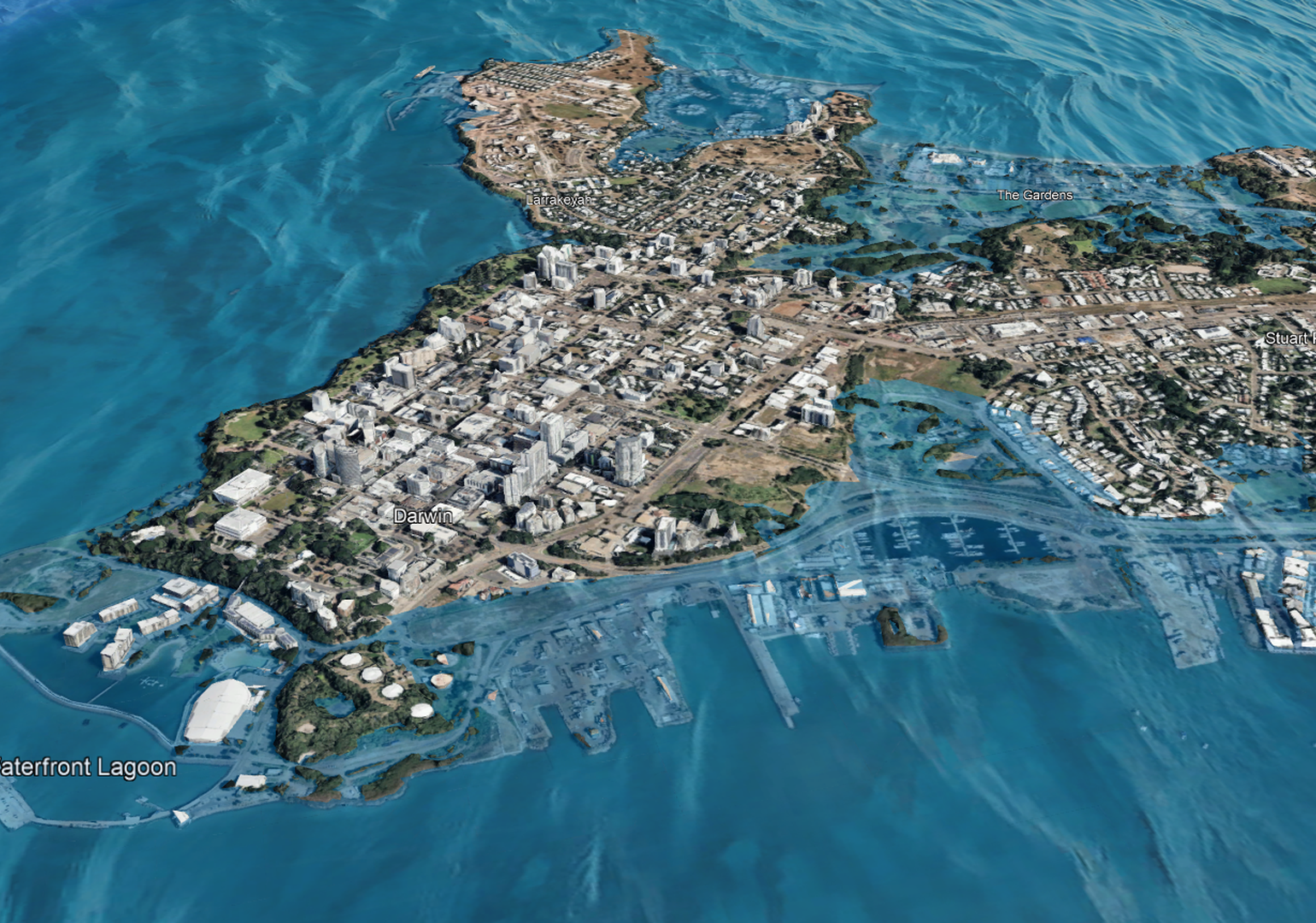
The Darwin inundation model (for illustration purposes only)
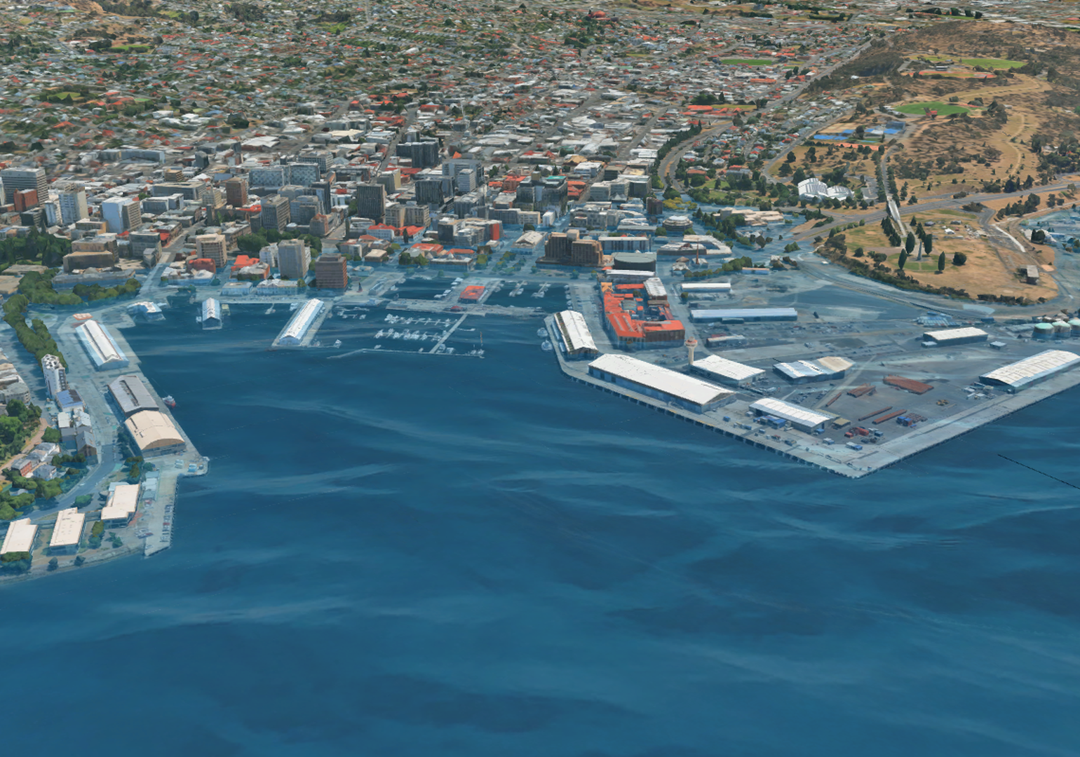
The Hobart inundation model (for illustration purposes only)
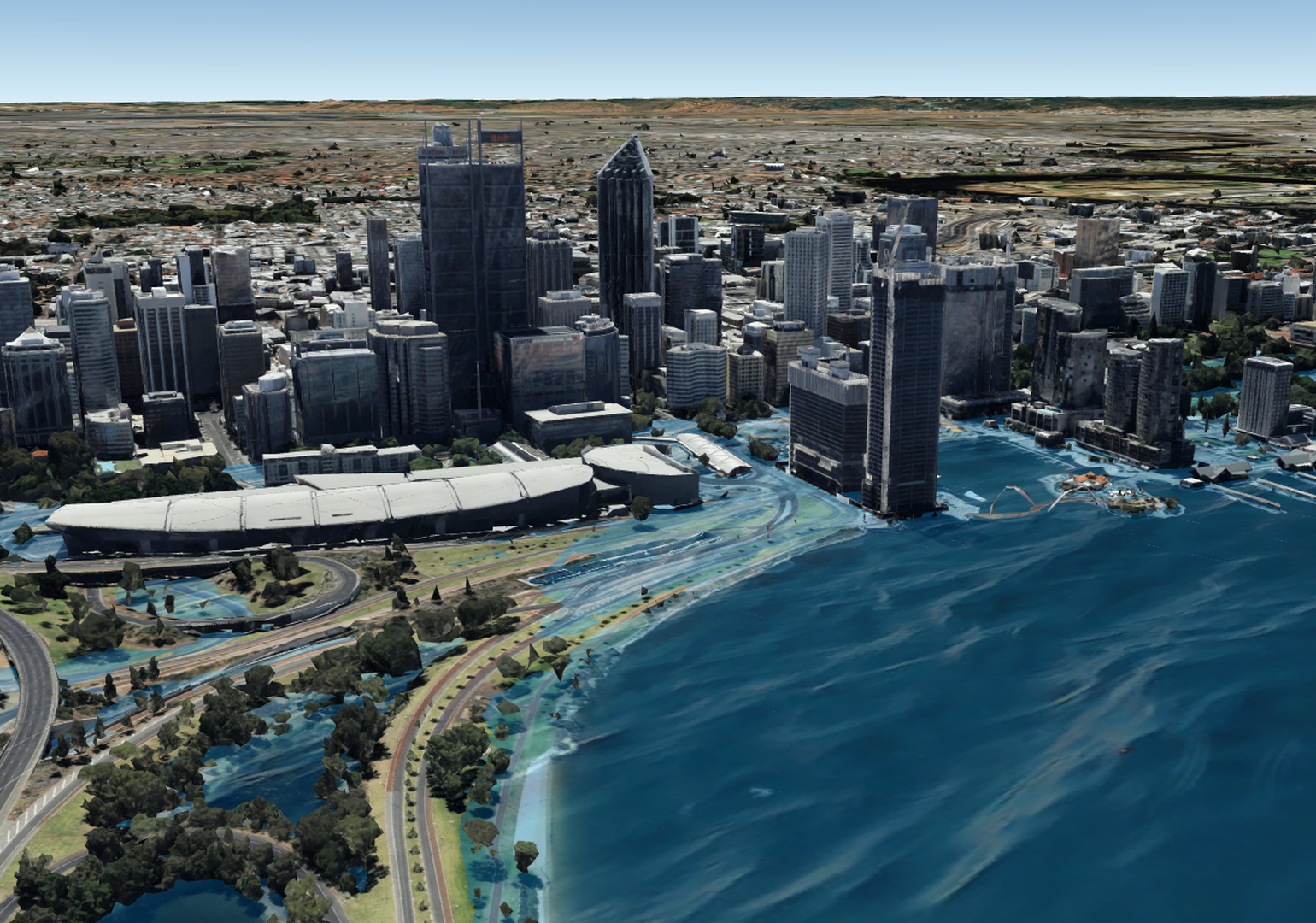
The Perth inundation model (for illustration purposes only)
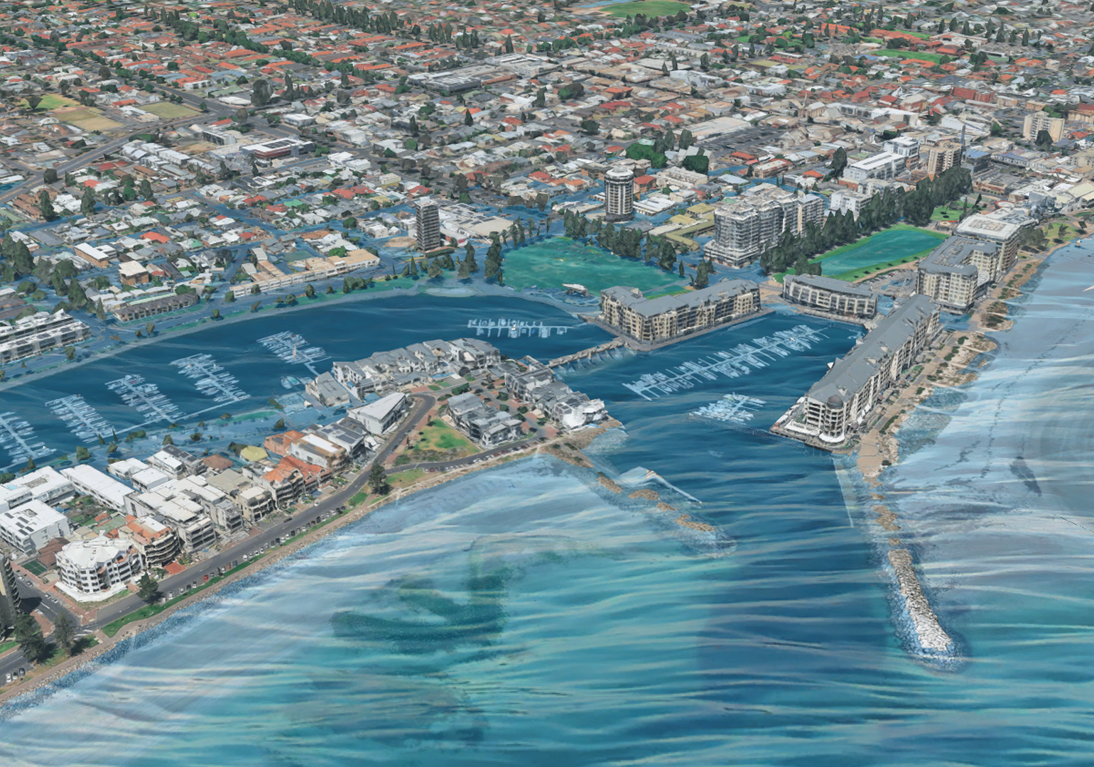
The Glenelg inundation model (for illustration purposes only)
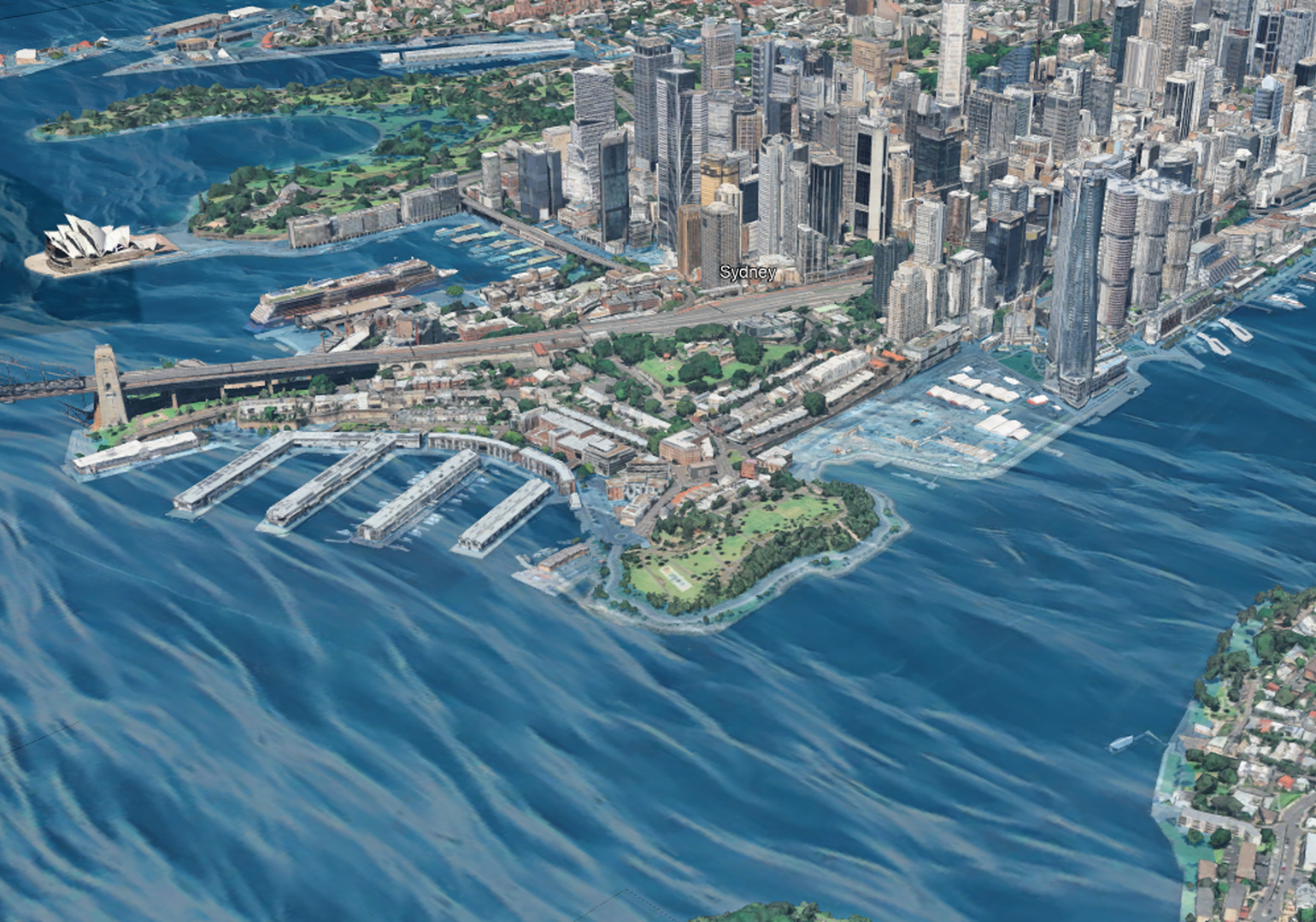
The Sydney inundation model (for illustration purposes only)

“Automation allowed us to apply the assessment consistently across a very large number of coastal segments and scenarios,” Nguyen said. “But automation does not replace engineering judgement. We still had to review the input data, test whether the results were physically reasonable and investigate outputs that did not fit our understanding of the coastline.”

Many conventional planning assessments communicate erosion hazard through a single setback line, indicating a single erosion extent. This project instead uses probabilistic analysis and Monte Carlo simulation to represent a distribution of possible outcomes and make the underlying uncertainty more visible.

“We might take sand from where it is accumulating and place it where it’s needed, then let nature … work on it and redistribute it within the system.”
Ryan Nguyen MIEAust CPEng

This offers engineers and other planners a more robust understanding of the likelihood and potential extent of the hazard, in turn enabling better decision-making around priorities and actions.

This emphasis on consistency has also been suggested in the Scientific Reports study, which said Australian coastal assessments have typically used different modelling approaches, resolutions, scenarios and hazard definitions. This has limited planners’ abilities to compare risk consistently outside of a small, specific region.

Protecting ports and more

A better understanding of the hazard doesn’t make the engineering problem easier to solve. It simply clarifies the exposure.

Hatch Global Director for Ports and Terminals Andrew Catto MIEAust CPEng said exposed assets around rising sea levels potentially include almost everything engineers design and maintain near the coast. That includes homes and commercial developments, roads, rail, electricity, water and wastewater networks, telecommunications, airports, industrial facilities and ports, to name a few.

Ports present a particularly fascinating engineering challenge, Catto said, because the infrastructure was likely designed decades ago and is expected to operate for many decades to come.

A major North American container terminal currently requires raising by around one metre, he said, to remain resilient for another century.

Andrew Catto MIEAust CPEng

“This is one of the main container terminals on the east coast, so throughput is astronomical,” Catto said. “To shut parts of that down and lift the terminal up to become resilient is open-heart surgery on a facility like that. It’s very challenging.”

The solution might require a combination of hardened shoreline protection and the raising of terminal surfaces and is further complicated by the fact that many ports are constructed on reclaimed land.

Portfolio of actions

Speaking of reclaimed land, Nguyen spent many years as the lead project manager for the development of a long-term coastal adaptation master plan in Singapore.

“Being a small island state, they have nowhere to retreat,” he said.

Nguyen describes a good adaptation strategy as a portfolio of measures tailored to local conditions, which could include planning controls, emergency preparedness and insurance, alongside engineered interventions such as dikes, revetments, storm surge barriers, tidal gates and flood-resilient design.

Singapore provides an excellent, if extreme, example. Roughly 80 per cent of its shoreline has already been hardened by ports and other development, according to Nguyen.

Ryan Nguyen MIEAust CPEng

From his experience in Singapore and his new insight in South Australia, Nguyen said it’s important to realise that not every response involves concrete and steel. Often the best course of action is to work with nature.

“Sometimes it will be our job to recycle the sediment within the coastal system,” Nguyen said. “We might take sand from where it is accumulating and place it where it’s needed, then let nature – the winds, waves, currents and tides – to work on it and redistribute it within the system.”

But neither nature nor infrastructure can ensure the protection of every asset against a rising sea. Some places and assets will demand harder choices. Planned retreat will become necessary for some residential, commercial and even industrial developments, Catto said.
“To shut parts of that down and lift the terminal up to become resilient is open-heart surgery.”
Andrew Catto MIEAust CPEng

That means coastal engineering will increasingly become about going “beyond the technical”, Catto said.

Engineers can analyse probabilities, model erosion and design defences. But the communities and governments behind those seawalls must figure out what level of residual risk is acceptable, and when they are no longer prepared to do and spend what it takes to reduce that risk.

And so, along tens of thousands of kilometres of coastline and infrastructure, not all of which can be defended, Australia’s first engineering task is not necessarily to build more barriers. It is to develop a consistent evidence base for prioritising coastal protections, what can be adapted and where future exposure should be avoided.

Disclaimer: The five-metre water level used to depict possible future inundation impacts is for illustrative purposes only. It represents a hypothetical total coastal water level that could occur under extraordinary circumstances where storm surge and high tide combine on top of future sea level rise. It is not a site-specific forecast, model output or direct IPCC sea-level rise projection.

UPCOMING WEBINAR: Lessons from the Bribie Island breakthrough and closure

Tags: climate changecoastal engineeringrising sea levelscoastline resilience
Previous Post

This facility can process 160,000 t of contaminated soil annually

Next Post

Before and after: 10 major infrastructure projects that have transformed Australian cities

Chris Sheedy

Chris Sheedy

Chris Sheedy is a professional writer whose work has taken him to the UK, USA, Europe and China. He has a fascination with big things - ideas, organisations, infrastructure, achievements, brands - and the people and processes required to make them a reality.

Related Posts

Building the museum that bridged past and present
Projects

Building the museum that bridged past and present

8 October 2026
Whiteboard to dashboard: A practical path to productivity in construction
Features

Whiteboard to dashboard: A practical path to productivity in construction

8 October 2026
Microplastics, major problems
Materials

Microplastics, major problems

8 October 2026
Next Post
Before and after: 10 major infrastructure projects that have transformed Australian cities

Before and after: 10 major infrastructure projects that have transformed Australian cities

Leave a Reply Cancel reply

Your email address will not be published. Required fields are marked *

create is brought to you by Engineers Australia, Australia's national body for engineers and the voice of more than 120,000 members. Backing today's problem-solvers so they can shape a better tomorrow.
  • ABOUT US
  • CONTACT US
  • SITEMAP
  • PRIVACY POLICY
  • TERMS
  • SUBSCRIBE

© 2024 Engineers Australia

No Result
View All Result
  • Technology
    • BIOTECH
    • COMMUNICATIONS
    • COMPUTING
    • IMAGING
    • MATERIALS
    • ROBOTICS
    • SOFTWARE
  • Industry
    • DEFENCE
    • INFRASTRUCTURE
    • INNOVATION
    • MANUFACTURING
    • POLICY
    • PROJECTS
    • TRANSPORT
  • Sustainability
    • ENERGY
    • ENVIRONMENT
    • RESOURCES
  • Community
    • CULTURE
    • PEOPLE
  • Career
    • EDUCATION
    • INSPIRATION
    • LEADERSHIP
    • TRENDS
  • About
    • CONTACT
    • SUBSCRIBE