

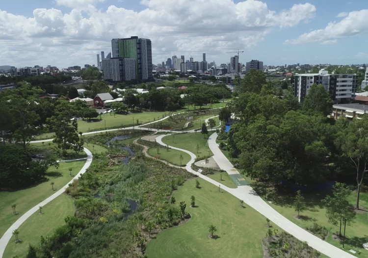
A concrete stormwater channel in Brisbane has been transformed into a meandering stream through lush parkland, representing a new, sustainable side of engineering.
It took several years of design and consultation to transform a functional but unsightly stormwater channel into a 600 m creek through parkland that is now popular with children and adults alike.
Most importantly, the reinvention of Brisbane’s Hanlon Park required excellent engineering work.
“We think it might be the most significant creek naturalisation project in Australia,” said Alan Hoban, Director of Stormwater Australia and Director and Principal Engineer at Bligh Tanner, the design lead on the Brisbane City Council project.
“The engineers 100 years ago had one focus, which was flooding and drainage and getting water away as quickly as possible. The local catchment group realised something better could be done.”
People power and a forward-thinking team at Brisbane City Council helped make the vision a reality. But along the way from concrete drain to creek re-naturalisation were numerous challenges, Hoban said.
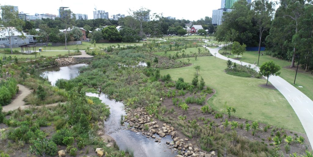
First and foremost was the ever-constant threat of flooding. “The area has a 30 km2 urbanised catchment upstream of it,” he said. “You don’t need much rain in that catchment to cause flash flooding through the site.
“So we were transitioning from something that was the ultimate engineering of last century. Back then, they turned waterways into geometric drains that were optimised to convey water really quickly. And they did that job very well; the engineers were highly competent.
“When you want to change that and start naturalising it, adding plants, bends in the water course and other features, you invariably slow water down. To compensate for that we needed to do significant bulk earthworks.
“So it’s a very complex engineering task in terms of optimising that design to make sure we weren’t making flooding any worse for anybody.”

Flood resilience
Recent flooding in Queensland has proven conclusively that no stormwater drainage system can cope with the worst of what nature offers.
The infrastructure must simply continue to perform — it must survive the event. The Hanlon Park re-naturalisation project, a far softer landscape, was tested and proven several times during and after its completion.
“We had four decent-sized floods during construction, and one since,” Hoban said.
“So we didn’t even get to completion before we had it tested thoroughly. An open construction site with quite a number of flood events was a challenge and a frustration.
“But it all worked because we had done a lot of engineering analysis to understand the velocities and erosive forces of the creek. That’s why it didn’t just get ripped apart.”
The iterative design process began with sketches: quick designs that allowed the team to consider potential water movement options.
The team spent a great deal of time analysing maps of current waterways to begin locking down possible shapes and forms of the new creek.
Fixed constraints were then introduced. A major sewer line ran through the site — one of Brisbane’s biggest — which had a number of manholes and smaller feeder lines running across to the main pipe.
There was also a focus on active transport, including walking and bike routes, and bridges.
Where these features sat in the park and how they interacted with the creek had to be carefully planned.
“There was a reasonable amount of civil engineering, just thinking about the grades and levels of those paths and the bridge designs, and how they all work together,” Hoban said.
“Initial sketches were on paper, but software is now quite sophisticated, both in terms of earthworks terrain modelling software and the ability to create organic forms. You imagine that software is really good at drawing geometric forms, but we can now also use it to create organic ones.”
Flood modelling software enabled further iteration; Bligh Tanner used a package called Tuflow.
The software helped the design engineers produce maps showing exactly how deep the water might get across the site, how fast it could flow, and the effect of any change in the extent of flooding compared to the existing situation.
“Once we had those site results, we could see where we needed levels to be a bit lower or higher, so we might need more excavation,” Hoban said. “We probably ran through around 20 iterations of the design.”
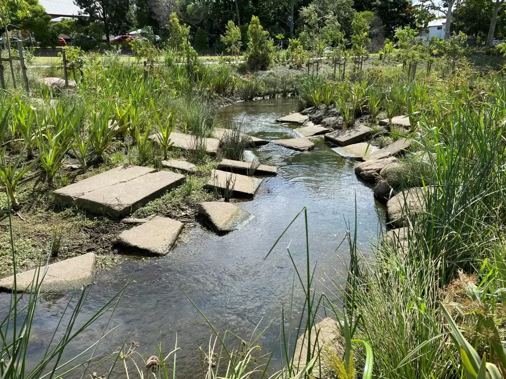
Surface materials were also a focus for flood resilience. They had to be designed so they would not erode under flooding, but they also had to slow water down to build a meandering creek.
Surfaces required a certain level of softness and greenery, appealing enough to engage people and to attract wildlife to the park, but safe for bicycles and pedestrians.
“Green infrastructure evolves over time,” Hoban said. “When you’re doing reinforced concrete, you know once it’s set pretty much how much strength you’ve got. But when you’re using vegetation, it might be 12 months to two years before that’s in place.
“So you need a really good approach to working with risk.”

Sustainability focus
There was a lot of concrete to dig up and drag away.
On such a high-profile — “gutsy and provocative”, as Hoban describes it — project that was sure to attract a lot of scrutiny, it was important to do the work in the most sustainable manner.
Bligh Tanner and construction firm Epoca Constructions agreed to re-use as much concrete as possible.
Much of it was used in the new site for landscape walls that double as places to sit and rest; for armouring the creek bed in high-velocity areas; and as stepping stones across the creek.
“Public parks are important places to showcase sustainability principles,” Hoban said. “People talk a lot about sustainability and resource conservation, but when people see it in action, that’s when it starts to resonate for them.”
The biodiversity benefits from such a project are also significant, Hoban said.
There are now fish in the creek and their numbers are increasing. With the numerous varieties and levels of vegetation, bird life has also boomed.
As urban areas increase in size, the heat island effect means such green spaces help to make those cities more liveable.
“These green-blue places in our cities become cooling places, and there’s a huge benefit to people in just being able to get close to — or into — water,” Hoban said. “We really start to see some of that cooling benefit when we look at thermal imaging.
“It’s a pretty significant sustainability benefit provided to the local community.”