
How it works
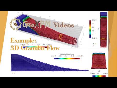
GeoXPM is the first fully functional continuum particle-based software to model and predict the onset and post-failure responses of geomaterials and geo-structures as they undergo significant deformations across several scales.
“For example it can be used to evaluate the potential risk of an earth structure failure when exposed to earthquake loads,” Bui said. “Similarly, GeoXPM can predict the likelihood of failure of an earth dam subjected to heavy rainfall.”
The software can also model other complex processes of soil-structure interactions, soil-fluid mixtures, fracture and fragmentations of rock and concrete – which are helpful for geotechnical designs and optimisations. Notably, GeoXPM software excels in foreseeing the aftermath of failures.
Let’s consider geo-disasters through the lens of debris flows or tailing dam collapses.
These events often involve the rapid downhill movement of geomaterials, debris or tailing dam materials at high speeds – capable of damaging surrounding infrastructure while claiming lives along the way.
Certain crucial aspects of these events remain unknown, such as the size of the collapse, the potential distance the flow could cover, and the areas most susceptible to impact. But this is where the software comes into play, Bui said.
“By simulating these processes, we can gain an in-depth understanding of them,” he said. “We can then design downstream systems, such as baffles and check dams, which divert the flow away from densely populated areas or slow down material movement, reducing its impact on infrastructure and saving lives.”
What’s next?
GeoXPM is tailored to benefit both engineers and researchers. For engineers, the software is a valuable tool to evaluate risks such as earth structure failures, contributing to enhanced safety measures through proactive preparation for potentially disastrous incidents.
Researchers can harness GeoXPM to tackle intricate geotechnical challenges, leading to advancements in practical designs and solutions.
With GeoXMP now fully developed, the team is working out the logical next steps.
“We are currently assessing the level of interest from potential customers among our users,” Bui said. “GeoXPM has attracted over 15,000 website visitors worldwide in just two months since its release, so we are considering opportunities to engage with industries and potentially enter the commercial market.”
Future plans for GeoXPM also involve maintaining public access to the software, enabling civil engineers to assess potential geo-disasters and risks.
“We are committing to continuously updating the software with new features to enhance its predictive capabilities, while integrating GeoXPM with cutting-edge technologies such as satellite data and machine learning,” Bui said.
“This integration will pave the way for a ground-breaking early warning system for geo-disasters, focusing on practical applications and high accuracy.”
Hear from a stellar line-up of local and international speakers at the tenth biennial RISK conference, organised by the Risk Engineering Society. The theme this year is ‘Risk engineering for a resilient 2030’.