

Using “superior” data capture, remote inspection of sewers is helping engineers spot trouble before it bubbles up.
The thought of having to crawl into a sewer pipe 1.2 m in diameter is probably up there on many people’s “nope” lists. It was enough to make KBR’s National Digital Engineering Technology Manager Hayden Robinson – the one most likely to be entering the pipe for inspection – a strong advocate for finding an alternative method: a first-of-its-kind remote-controlled vehicle for sewer inspections.

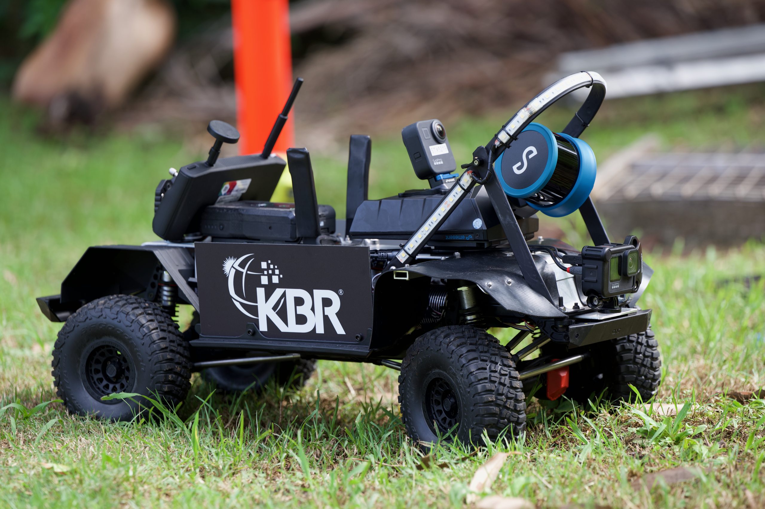
While sewer crawler cameras have been around for years, KBR wanted to raise the bar and partnered with Emesent, a simultaneous localisation and mapping technology (SLAM)-based mapping company, to build a remote-controlled vehicle (ROV) fitted with a Hovermap ST-X Mobile Laser Scanner and HD 360-degree CCTV technology.
“Because we’ve used the scanner on other infrastructure projects, and in other challenging environments, we identified it could be fit for purpose for this, and that started the ball rolling,” Robinson told create.
World-first scan
On its first official mission for Central Coast Council, the new ROV successfully scanned 640 m of sewer pipe, making it the first ROV in the world to use SLAM over that length and in that diameter.
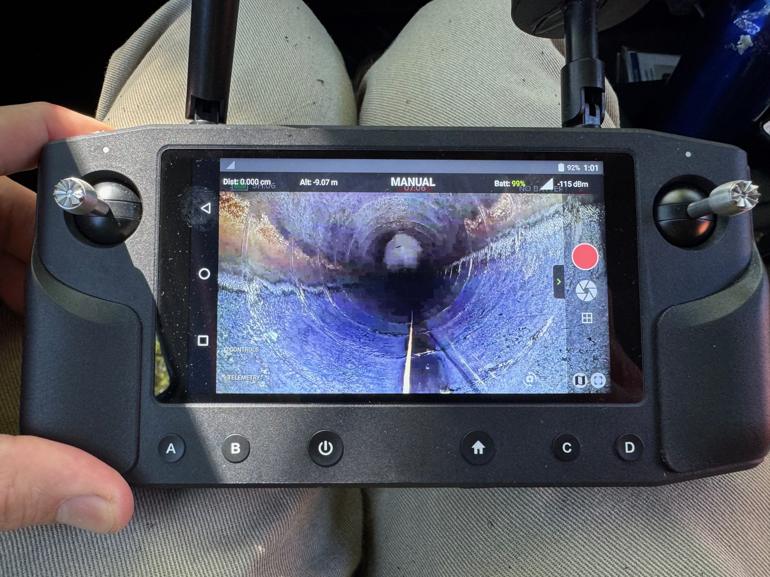
“A lot of the crawlers are tethered for power and control, but we used a remote-control antenna – much the same as a drone – which meant we could maintain visual and transmission contact between the ROV and the control,” Robinson said. “We configured an extendable range antenna 20 m long.”
He noted a requirement from Central Coast Council was to be able to control the ROV from the surface, eliminating a key safety hazard of people entering drainage pipes.
Read more: How remote operations are increasing safety for engineers
Another challenge to overcome was the need to be able to see where the operator was driving the ROV.
“Originally we just had a camera on the front which gave us live feed video and recording, but during a trial we realised we needed to be able to see behind in case we needed to reverse, so we had to integrate a rear facing camera as well, both for the first-person view and for the data capture, and then integrate that into the remote control.”
Data capture a “gamechanger”
Data capture presented its own set of problems. LED lights were added front and back, a rollbar was integrated to protect the scanner, and a GoPro 360 was also added to colourise the point cloud and also capture a 360-degree video which can then be used as a visual tool for post inspection.
The ROV also needed to be able to physically track itself and be able to map the long, linear, uniform shape of the pipe which previous scanners had struggled with.
However, it is the end use of the data capture that Robinson feels sets this ROV apart.
“When we upload the data to Cintoo, a cloud-based digital twin platform, we can extract 360-degree images along the trajectory at set intervals. We can set a metre, two metres, three metres et cetera, and then upload the point clouds with those export images so you can view the point cloud as a 3D model. You can actually go into the individual 360 images and look at a much higher definition, more photorealistic image of the asset.
“Our data capture is far superior. It gives engineers more information to be able to do a condition assessment on a particular asset. Rather than just having a traditional CCTV, which will just have a video, and maybe a chance so they can work out where they are in that video, they’ve got a 3D point cloud, which is geo-referenced, and associated 360-degree video imagery.”
The digital replica allows engineers to interrogate what the design profile of the pipe was, what it should be, and what it is now. At the moment, the ROV is restricted to empty pipes, but Robinson said the versatility of the scanner means it can be used on a vehicle, drone and devices that float, so eliminating the need to drain the pipe first is a future project.
He described the ROV as a gamechanger, in safety, efficiency and cost effectiveness.
“It’s using technology to provide information that allows people to be able to do their jobs better. Being able to capture the data is one thing, but then being able to make use of that data is the real value add.”
Find out whether Australia is ready to embrace autonomous technology in the rail industry at this on-demand webinar.


Quite fascinating! I’ve heard various batch mates of my cohort bounce around these ideas during Masters. Interesting to learn that the idea being successful materialised, keen to see the commercial aspect of the innovation.